ICGEM – International Centre for Global Earth Models
Overview
The determination of Earth’s global gravity field is one of the main tasks of geodesy: it serves as a reference for geodesy itself and provides essential information about the Earth, its interior and its fluid envelope for all geosciences. Thus, it is important to model the gravity field globally and make the state-of-the-art models available to public as geodetic products. With accurate satellite measurements, it is now possible to map the static gravity field as well as its variations with much higher spatial and temporal resolutions compared to the first of its kinds. The list of such models is continuously growing and requires dedicated maintenance.
International Centre for Global Earth Models (ICGEM) is one of the five services coordinated by the International Gravity Field Service (IGFS) of the International Association of Geodesy (IAG). The primary objective of the ICGEM service is to collect and archive all existing static and temporal global gravity field models and provide an online interactive calculation service for the computation of gravity field functionals freely available to the general public. The calculation of the different functionals of the geopotential (e.g. geoid, gravity anomaly, gravity disturbance, equivalent water height) from a defined global model, on a specified grid or points with respect to a defined reference system, is not trivial for science and scientists and is a responsibility of geodesy too. Additionally, it is important to visualize the spatial and temporal distribution of the global gravity field and therefore interactive visualization is also provided by ICGEM.
Objectives
With the initiation of IGFS and the commitment for hosting and financial support by German Research Centre for Geosciences (GFZ), the ICGEM service was established in 2003 and comprehends:
– collecting and long-term archiving of existing static global gravity field models, solutions from dedicated shorter time periods, and topographic gravity field models,
– making the above-mentioned models available on the web in a standardized format as described in Barthelmes and Förste (2011),
– assigning Digital Object Identifiers (DOIs) to the models,
– a web interface for the calculation of gravity field functionals from the spherical harmonic models on freely selectable grids and user-defined points,
– a 3-D interactive visualization of the models (geoid undulations and gravity anomalies),
– quality checks of the static gravity field models via comparisons with other models in the spectral domain and w.r.t. GNSS/levelling-derived geoid undulations,
– the visualization of surface spherical harmonics as tutorial,
– the theory and formulas of the calculation service documented in GFZ’s Scientific Technical Report STR09/02 (Barthelmes, 2013),
– manuals and tutorials for global gravity field modelling and usage of the service (Barthelmes, 2014) and scientific journal papers for educational and reference purposes (Ince et al. 2019) and finally,
– the ICGEM web-based gravity field discussion forum for questions on ICGEM, its products, and knowledge exchange.
Services
The Models
Static gravity field models, models from dedicated time periods, and topographic gravity field models of the Earth and gravity field models of other celestial bodies and since recently simulated gravity field models for new generation gravity missions are available in the form of spherical harmonic coefficients.
Digital Object Identifiers (DOI)
To support open science and citable data, ICGEM assigns DOIs together with the GFZ Library and Information Services. DOI # requests can be made via: http://pmd.gfz-potsdam.de/panmetaworks/metaedit/.
The 3D Visualization
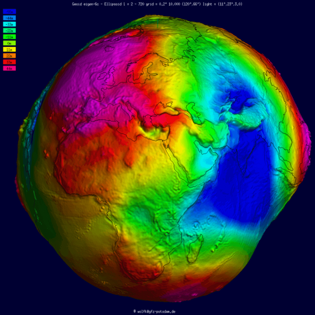
An online interactive service for the visualization of the models (in terms of height anomalies and gravity anomalies) as illuminated projection on a freely rotatable sphere shown in Fig. 1 is available (http://icgem.gfz-potsdam.de/vis3d/longtime).
Fig. 1 Visualization (geoid) of a global gravity field model.
The Calculation Service
A web-interface to calculate gravity field functionals from the spherical harmonic models on freely selectable grids (http://icgem.gfz-potsdam.de/calcgrid) or at user-defined points with respect to a reference system of the user’s choice (http://icgem.gfz-potsdam.de/calcpoints) is provided. The following functionals are available in the grid calculation:
• pseudo height anomaly on the ellipsoid (or at arbitrary height above the ellipsoid)
• height anomaly (on the Earth’s surface)
• geoid height (height anomaly plus spherical shell approximation of the topography)
• gravity disturbance
• gravity disturbance in spherical approximation (at arbitrary height above the ellipsoid)
• gravity anomaly (classical and modern definition)
• gravity anomaly (in spherical approximation, at arbitrary height above the ellipsoid)
• simple Bouguer gravity anomaly
• gravity at the Earth’s surface (including the centrifugal acceleration)
• gravity on the ellipsoid (or at arbitrary height above the ellipsoid, including the centrifugal acceleration)
• gravitation on the ellipsoid (or at arbitrary height above the ellipsoid, without centrifugal acceleration)
• second derivative in spherical radius direction (at arbitrary height above the ellipsoid)
• equivalent water height (water column)
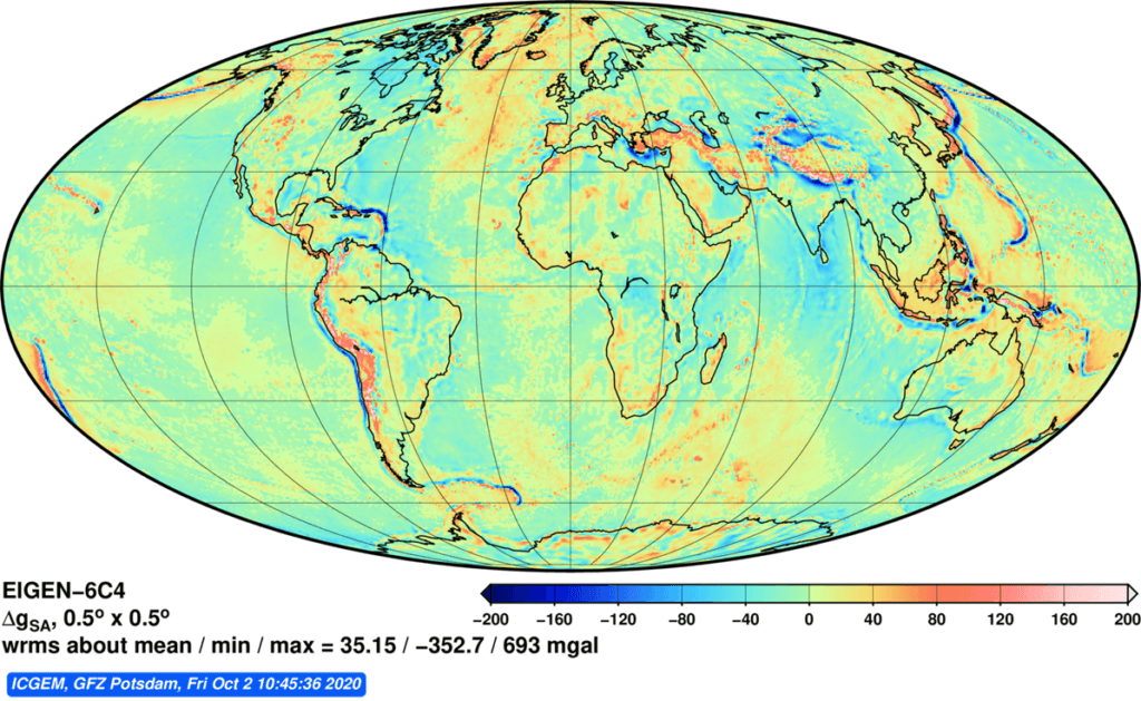
For grid calculations, the corresponding plots created using GMT (in Postscript or Portable Network Graphics format) are available for download (see Fig. 2 for an example).
Fig. 2 Example of grid and plot generation: EIGEN-6C4 global gravity anomalies.
G3 Browser
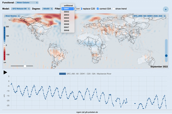
The G3 (GFZ GRACE Gravity) Browser computes time series of equivalent water height over a global grid, river basin or on a user defined point interactively and gives users the opportunity to compare different series in terms of water column, geoid and gravity disturbances and introduce corrections (e.g., GIA, C20) as well as compare the impact of various filters. The service is complementary to existing services and the results can be downloaded freely as xyz-ascii grids and csv files. Its main aim is to provide an educational portal for students, teachers and researchers.
Fig. 3 G3 Browser Portal (Functional, Model, Degree, Filter, and corrections can be selected by the user).
Evaluation of Models
ICGEM evaluates the static gravity field models w.r.t. GNSS/levelling derived geoid undulations (http://icgem.gfz-potsdam.de/tom_gpslev) and in the spectral domain w.r.t. already reliable models (http://icgem.gfz-potsdam.de/evalm).
Public outreach
To support the users from different disciplines and levels, ICGEM answered the Frequently Asked Questions (http://icgem.gfz-potsdam.de/faq). Also, to update the users for new products and stimulate the knowledge exchange with and among them, ICGEM’s discussion forum is expanded and an e-mailing list (icgemusers@listserv.dfn.de) has been created.
Outlook
ICGEM is a worldwide service and provides a unique platform to collect and provide access to a comprehensive list of gravity field models that are of static, temporal and topographic kind. It continues to update its content with new models and additional features as requested by the users, and depending on availability. Beside the calculation and visualization services, complementary documentations about the models are made available. The coordination and communication of the ICGEM Service are made through the ICGEM staff (icgem@gfz-potsdam.de) with input from international contributors.
Data Policy
Access to global gravity field models, derived products and tutorials, once offered by the center, shall be unrestricted for any external user.
Reference
Reference for ICGEM Service and its products is as follows:
Ince, E. S., Barthelmes, F., Reißland, S., Elger, K., Förste, C., Flechtner, F., and Schuh, H.: ICGEM – 15 years of successful collection and distribution of global gravitational models, associated services, and future plans, Earth Syst. Sci. Data, 11, 647–674, https://doi.org/10.5194/essd-11-647-2019, 2019.
Other references:
Barthelmes, F.: Definition of Functionals of the Geopotential and Their Calculation from Spherical Harmonic Models: Theory and formulas used by the calculation service of the International Centre for Global Earth Models (ICGEM), Scientific Techni- cal Report STR09/02, Revised Edition, January 2013, Deutsches GeoForschungZentrum GFZ, https://doi.org/10.2312/GFZ.b103-0902-26,2013.
Barthelmes, F.: Global Models, in: Encyclopedia of Geodesy, edited by: Grafarend, E., Springer International Publishing, 1–9, https://doi.org/10.1007/978-3-319-02370-0_43-1, 2014.
Förste, C, Barthelmes, F. and Ince, ES: The ICGEM-format. Potsdam: GFZ German Research Centre for Geosciences, available at: http://icgem.gfz-potsdam.de/ICGEM-Format-2023.pdf (last access: 11 December 2023), 2023.
Staff
ICGEM is hosted by GFZ Potsdam. After the long-time director of the ICGEM service Franz Barthelmes’ retirement, current staff consists of
• E. Sinem Ince (director)
• Sven Reißland
• Christoph Förste
The staff is allocated part-time and responds to queries on a best-effort basis.
Point of Contact
E. Sinem Ince
Helmholtz Centre Potsdam
GFZ German Research Centre for Geosciences
Telegrafenberg,
D-14473 Potsdam,
Germany
E-mail: elmas.sinem.ince@gfz-potsdam.de
(last update 12.2023)


